


Credit: Richard Baker / In Pictures via Getty Images Images)


It’s just over an hour from London by high-speed train, but the isle of Thanet in East Kent feels very distant from the capital. This is marginal country: a flat and watery Saxon landscape so visually distinct from the Kentish hills and orchards it borders that it might be a part of East Anglia, or Jutland, eroded and washed ashore, far from home. Though the Wantsum Channel, the narrow waterway which once separated the isle from the British mainland, has long since silted up, the sense of apartness — of a “Planet Thanet” somehow removed from the affairs of the rest of the country — endures.
Viewed on a clear day from the chalk cliffs of Ramsgate, the matching white cliffs of France’s Cap Blanc Nez, our isle’s separated geological twin, shimmer on the horizon. In 1940 newsreels, Goering was famously shown peering at a defiant Britain from over there, no doubt picking out the town’s landmarks — the tall church spires that guided ships into harbour, the gaps and folds between the dazzling cliffs — through his binoculars. Heavily bombed in World War Two, and the marshalling point for the Little Ships of the Dunkirk evacuation, Ramsgate and Thanet’s proximity to continental Europe, source of both threat and promise, has shaped the region from the beginning of Britain’s recorded history. Perched on the edge of England, surrounded on three sides by the North Sea, the Isle of Thanet is simultaneously both marginal and central to our island’s story. Wherever it was finished, the first draft of the nation’s history was always written here.
Joined to Ramsgate by the village of Pegwell — a series of flint-walled cottages perched precariously on chalk cliffs concealing tunnels that lead to long-disused smugglers’ caves — sweeps the broad expanse of Pegwell Bay. For thousands of years the bay’s sombre mudflats, quaking bogs and salt marshes, patrolled by long-legged wading birds and basking seals, have served as the first beachhead for migrants and adventurers, missionaries and invaders making their way to this island.
It was here, in 2017, that archaeologists discovered the expeditionary fort built by Julius Caesar in 54 BC to defend his newly-landed legions from the hostile Celtic tribesmen, and here that the legions of Claudius returned in 43 AD, this time to stay. Here, too, were the great oyster beds of Ritupiae, singled out by Roman gourmets like the poet Juvenal for special praise, part of the network of trade and empire linking this lonely shoreline to the great hub of Mediterranean civilisation.
On the other side of the bay, the great flint fort of Richborough, built half a millennium of Roman rule after Caesar splashed ashore, failed to dissuade Saxon raiders from seizing the island for their own.
According to legend, the Jutish brothers Hengist and Horsa, summoned by the Romano-British king Vortigern as mercenaries, first came ashore right here, beginning the process that carved out Saxon England from Celtic Britain. A wooden longship, a gift of the Danish government, commemorates this turning point, its dragon-headed prow looking fiercely out across the North Sea towards its distant homeland.

Under the later Saxon king Ethelbert, Pegwell’s lonely mudflats welcomed more peaceful continental migrants in the guise of St Augustine and his retinue of monks, sent wading ashore here on a mission to civilise the northern barbarians, an effort culminating in the great church of Canterbury and the beginning of England’s 1700-year Christian story. Even today, a fragment of the missionary saint’s bone is still revered in my local church, Pugin’s wondrous neo-Gothic confection of St Augustine’s, a dream in incense-clouded stone of England’s lost High Middle Ages. The England we live in now was birthed on this lonely stretch of low chalk cliffs and brown and squelching shore.
Where England ends, Europe begins, a geographic fact that built Ramsgate, the town where I live and write this. Still a modest fishing village wedged in a gap between the chalk cliffs, Ramsgate boomed as a result of the Napoleonic Wars. So many regiments passed through the town, so many warships and troop transports hugged the harbour for shelter, that ranks of Regency villas, handsome in brick and stucco, formed up along the cliffs to house the colonels and admirals, sea captains and majors quartered here.
By the war’s end, Ramsgate had played host to so many eligible officers that, in a fit of “scarlet fever” (named after their red uniforms), the town had become an extension of the London season, with fashionable debutantes and anxious spinsters alike hurrying down in flocks to bathe in the North Sea’s chill green waters and marry well. Ramsgate’s street names — Wellington Crescent, Plains of Waterloo, La Belle Alliance Square — still bear witness to this brief moment of Regency glamour, when hussars and dragoons clip-clopped along the fishing port’s cobblestones to board the ships that would take them to death or glory in the continent’s wars.
The postwar peace cemented Ramsgate’s status as England’s fashionable resort of choice. Lords Canning and Liverpool strolled the town’s leafy squares discussing the business of government. King George IV and Princess Victoria holidayed here, splashing in the brisk North Sea, and delighting the local burghers with their regal presence. Wilkie Collins summered here, as did Dickens before he settled on the more firmly genteel charms of Broadstairs, just along the coast. Karl Marx, too, would holiday here with his long-suffering family, putting aside his lifetime’s work of global revolution for a week or two to enjoy the minstrel bands on the seafront promenades, dashing off brief notes on Europe’s political convulsions to his fellow revolutionaries while Mrs Marx and the children picnicked on the sands with Engels.
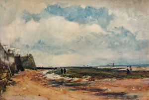
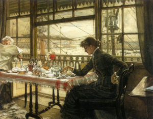
Along with kings and revolutionaries, statesmen and writers, the town attracted artists in its heyday. William Powell Friths’s 1854 painting Ramsgate Sands — bought by Queen Victoria to remind herself of her childhood holidays — captures the crowds of mid-Victorian holidaymakers down from London by train, paddling, fully-clothed, in the lapping water, sheltering under umbrellas from the sun in their top hats and hooped skirts. The French painter James Tissot sketched fashionable ladies in crinoline taking tea overlooking the mast-filled harbour, while an impoverished Vincent Van Gogh taught art in a squalid school here for his room and board while admiring the “harbour full of all kinds of ships, closed in by stone jetties running into the sea on which one can walk,” where “further out one sees the sea in its natural state, and that’s beautiful.” Writing to his brother Theo, praising the shafts of light that burst through the black clouds after a squall, Van Gogh observed “this town has something very singular; one notices the sea in everything.”
Turner, a regular visitor to neighbouring Margate, famously remarked in a similar vein to Ruskin that “the skies over Thanet are the loveliest in all Europe,” a quality given to them by the North Sea, which forms the clouds that reflect the dying sun’s most lurid moods. Still the violent drama of their sunsets — the livid reds and golds, oranges and pinks — make the sea and sky seem more real and vivid than the ground you stand on. Indeed, living here feels, at times, more like living out at sea than on land.
All through the year, sudden sea mists drift ashore and blanket the town in white cloud. The lights of fishing boats blink out at sea through the chill fog even as the road in front of you is swallowed by the gloom. In winter, the North Sea winds make the town’s Victorian houses list and creak like wooden ships in high swell, as waves of rain lash against their window glass. Cars and fixtures rust quickly here, wooden doorframes and windows peel and warp in the harsh salt air. The trees along the seafront are bent sideways by the wind; the salt sea air smells sharp, and fresh, like a living thing caught wriggling in a net.
As far back as 1536, the essayist William Camden remarked that Thanet’s locals were “as it were amphibious creatures, and get their living both by sea and land; for they deal in both elements, and are both fishers and ploughmen; for the same hand that holds the plough, steers the ship likewise.” Smugglers and wreckers as well as fishermen, the locals were viewed with some disfavour by the Customs men sent down by Whitehall to disrupt their illicit trade with the continent. “The seamen here are generally reputed excellent sailors, and shew themselves very dextrous and bold in going off to succour ships in distress,” stated an early 19th century visitor, “but they are too apt to pilfer stranded ships, and ruin those who have already suffered so much.”
The sudden winter storms still disgorge many treasures for Thanet’s dog walkers and beachcombers. Every year, cannon balls and human bones, hunks of amber and painted porcelain are washed ashore from the vast ships’ graveyards lying out at sea, onto the treacherous and shifting sandbanks that reveal themselves, like the smuggler’s tunnels in the chalk, only at low tide.
A local economy based on smuggling, tourism, fishing and European war has not prospered from the modern era. Like the rest of Thanet, Ramsgate is one of the most deprived areas of the country, sharing little of Southeast England’s wealth. Unemployment is high, life expectancy is low, and better times seem always, like France, barely visible on the horizon. The crumbling Regency and Victorian townhouses, no longer home to scarlet-coated officers or holidaying revolutionaries, have recently attracted another wave of invaders — middle-class London families like my own, priced out of the capital and displacing locals in turn.
Thanet’s locals and its new army of DFLs — Down From Londoners — still live not-quite integrated lives. Like the rest of Britain, only somewhat more so, in Ramsgate the Somewheres and the Anywheres live jostled side by side. Home, until recently, to the only Ukip-run council in the UK, Thanet’s relationship with the European continent is still an ambiguous thing, and the vote for Brexit here, at 64%, was among the highest in the country.
These tensions find expression in micro-local culture wars, like the battle to re-open the old RAF Manston airfield as a commercial hub. An anti-airport poster in a window here, like an EU flag or BLM placard, is an almost certain signpost of a Londoner-in-exile, as much a marker of gentrification as doors and windows in the sombrest Farrow and Ball shades.
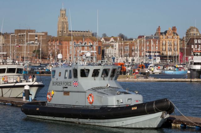
Proximity to the continent is writing Thanet’s history still. An RAF A-400 plane is, as I write, flying back and forth, skimming low above the sea outside my office window, scanning for the migrant boats which are landing in ever-increasing numbers. It is a strange and troubling vision of modern Britain to paddle in the sea with your children while a grey Border Force cutter patrols just offshore, searching for the latest boatloads from the coast of France. Distant past and present still collide here, peace and war, Britain and Europe and the wider world beyond still meshing in strange and unexpected ways as, perhaps, they always have and always will.

Join the discussion
Join like minded readers that support our journalism by becoming a paid subscriber
To join the discussion in the comments, become a paid subscriber.
Join like minded readers that support our journalism, read unlimited articles and enjoy other subscriber-only benefits.
Subscribe